Aspect Avy App Review
Aspect Avy is a preventative avalanche safety app designed to assist backcountry skiers, snowboarders, and other outdoor enthusiasts by providing real-time avalanche data integrated into detailed map visualizations.
Developed by avalanche experts, the app aims to simplify decision-making in avalanche-prone areas using up-to-date forecasts, slope angle information, and historical accident data. By offering easy-to-understand visual indicators, Aspect Avy helps users navigate safer terrain choices.
For the whole scoop, keep reading, or listen to our full review right here:
Features and Functionality
Key Features:
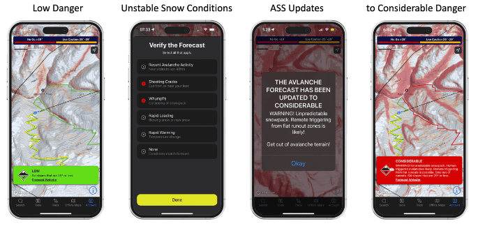
- Real-Time Avalanche Conditions: Integrates current avalanche forecasts directly onto detailed maps, using color-coded indicators to highlight risk levels, making it easier for users to interpret the data and make informed decisions.
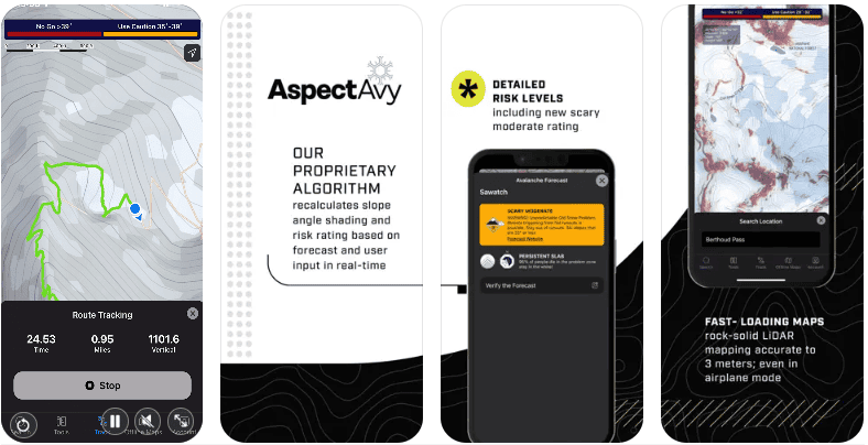
- LiDAR-Based Mapping: Utilizes high-resolution LiDAR mapping to provide more accurate and detailed slope angle data than traditional maps. This precision helps identify smaller, dangerous pockets that could be missed by other tools.
- User-Contributed Observations: Users can add real-time observations such as cracks, whumping, and slides, which update the app’s predictive features, helping to improve safety predictions over time.
- Simple Visual Cues: The app employs a straightforward “go/no-go” color system (orange for caution, red for no-go) to indicate safe and unsafe zones, reducing the ambiguity often seen in traditional avalanche reports.

Best Use Cases
Who is this app for?
Aspect Avy is ideal for backcountry skiers, snowboarders, mountaineers, and even casual hikers who need reliable, up-to-date information on avalanche risks. It is especially beneficial for those looking to avoid complex interpretation of standard avalanche reports.
When should you use this app?
Use Aspect Avy during pre-trip planning, while navigating through avalanche-prone areas, or when traveling in new terrain where avalanche risks are a concern.
Why We Love Aspect Avy
- Real-Time Safety: The app’s ability to integrate live avalanche conditions into detailed maps helps users navigate and make safer terrain choices.
- Precision Mapping: By using LiDAR technology, Aspect Avy provides a level of detail that can reveal hidden danger zones, making it more precise than traditional slope maps.
- Easy to Interpret: The app’s simple color-coded warnings minimize the need for complex data interpretation, providing clearer guidance for safer backcountry exploration.
Pros and Cons
Pros:
- High-resolution maps with real-time data integration.
- Simple visual indicators reduce confusion and make quick decision-making easier.
- Designed by experienced avalanche experts for practical use in the field.
- Regular updates, with plans to expand coverage beyond the U.S.
Cons:
- Limited to regions with reliable avalanche forecasts and LiDAR mapping; currently, this restricts coverage to specific areas in the U.S., with future plans for expansion.
- Requires a $50/year subscription, which may deter casual users.
User Experience and Interface
Design and Usability:
The app’s design focuses on simplicity and ease of use, ensuring that even users with minimal avalanche training can quickly understand the safety indicators. The intuitive interface makes it easy to plan routes and track progress.

Performance:
Users report smooth functionality, with maps loading quickly and real-time data integrating seamlessly. Preloaded maps work effectively offline, ensuring reliability even in remote areas.
Compatibility and Pricing
Platforms Supported:
- Available on iOS (unconfirmed on Android – could not find).
Cost:
- Aspect Avy offers a subscription model priced at $50 per year, which provides access to all features and updates.
Real User Reviews
What users are saying:
“The app’s simplicity and the real-time updates make it a must-have for anyone serious about backcountry safety.” – User feedback from outdoor community forums.

“Using Aspect Avy has given me more confidence to navigate safely through avalanche terrain, with clear indicators that take the guesswork out of the process.” – Early user review during beta testing.

Overall Rating:
4.5/5 stars, based on its practicality, ease of use, and focus on real-time data integration.
How to Get Started with Aspect Avy
Step-by-Step Guide:
- Download: Get Aspect Avy from the iOS App Store (could not find it on Google Play Store).
- Set Up and Subscribe: Choose your subscription plan and download maps for your planned destinations.
- How to Use: Plan routes, check live avalanche conditions, and utilize the app’s clear visual indicators to navigate safely.
Similar Apps
- onX Backcountry – Combines maps and avalanche safety features with offline navigation.
- CalTopo – Advanced mapping tools with detailed terrain analysis and custom map overlays.
- Avalanche Canada – Provides avalanche forecasts and safety information across Canada.
Final Verdict
Aspect Avy is a pioneering tool for anyone traveling through avalanche-prone terrain, combining high-resolution mapping with real-time data to make safer terrain choices accessible. With its focus on simplicity and practicality, it’s set to become an essential part of backcountry gear for skiers, snowboarders, and mountaineers. Though currently limited to specific regions, its planned expansions make it a promising investment for anyone serious about avalanche safety.
Download Aspect Avy Today

Ready to explore the backcountry safely? Download Aspect Avy and navigate avalanche terrain with confidence.
