PeakVisor Review
PeakVisor is an advanced 3D mapping and mountain identification app that caters to outdoor enthusiasts, including skiers and snowboarders. It provides detailed topographic maps, augmented reality (AR) features, and information on ski lifts and trails, making it a versatile tool for navigating mountainous regions. The app is especially useful in winter sports, offering features like real-time lift statuses and backcountry ski route details, combined with offline functionality for remote areas.
For the whole scoop, keep reading, or listen to our full review right here:
Features and Functionality
Key Features:
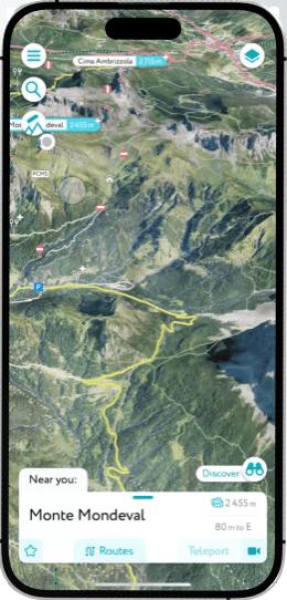
- 3D Topographic Maps: Visualize terrain with detailed 3D models, helping users understand the landscape of ski resorts, trails, and backcountry areas.
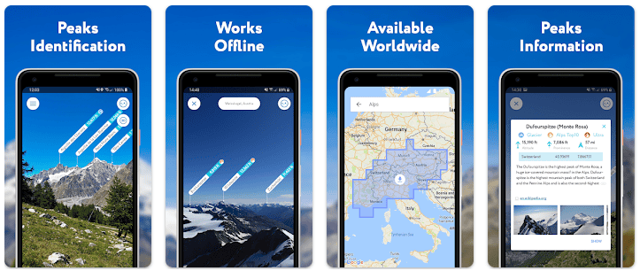
- Augmented Reality Peak Identification: Use your phone’s camera to identify nearby peaks, complete with names and elevations, turning your device into an interactive mountain guide.
- Ski Resort Information: Access real-time data on ski lifts, cable cars, and resort trails, including operating statuses and upcoming closures.
- Offline Access: Download maps and navigate without needing an internet connection, essential for backcountry skiing and remote locations.
- Import/Export GPX Files: Plan routes, track your adventures, and share or import GPX tracks for better route management.
Best Use Cases
Who is this app for?
PeakVisor is ideal for skiers, snowboarders, hikers, and mountaineers who need accurate mapping and terrain visualization. It’s particularly suited for those exploring new resorts or engaging in backcountry skiing, where real-time information and offline navigation are critical.
When should you use this app?
Use PeakVisor whenever you need to understand terrain, locate ski lifts, or navigate trails in the mountains. It’s particularly useful during skiing trips to unfamiliar locations or when planning backcountry routes.
Why We Love PeakVisor
- Advanced 3D Mapping: The app’s detailed 3D maps provide an intuitive understanding of the terrain, making it easier to navigate challenging areas.
- Augmented Reality Features: Identify peaks and other landmarks instantly, adding a layer of interaction that enhances the outdoor experience.
- Versatility: From identifying mountains to finding trails and managing routes, the app’s broad range of tools makes it useful across different activities.
- Offline Capability: Essential for adventures where internet access is unreliable, allowing users to download maps and plan ahead.
Pros and Cons
Pros:
- Comprehensive 3D maps and detailed topography.
- Real-time lift information, great for skiers.
- Effective offline functionality, suitable for remote areas.
- Easy-to-use AR features for identifying peaks.

Cons:
- Large data downloads may consume storage; best to download maps over WiFi.
- Subscription model may be expensive for casual users.
- Some users report a learning curve when navigating the app’s advanced features.

User Experience and Interface
Design and Usability:
PeakVisor has a clean, intuitive design that makes it easy to access features like peak identification and map navigation. Users can quickly switch to different modes, such as 3D maps or AR, to suit their needs. Some advanced functionalities may require a bit of learning, especially for first-time users.
Performance:
Generally praised for its accuracy and reliability, the app works smoothly even in offline mode. However, larger map files can slow down the initial setup, and heavy data use may be a concern for those on limited data plans.
Compatibility and Pricing
Platforms Supported:
Free vs Paid Version:
- PeakVisor can be downloaded for free, but full functionality requires a subscription. Monthly and annual plans are available, with a lifetime option for those who want permanent access.
Pricing:
- $4.99/month, $29.99/year, or $89.99 for a lifetime plan.

In-App Purchases:
- Subscriptions unlock all features, including offline maps, unlimited peak identification, and advanced 3D map access.
Real User Reviews
What users are saying:
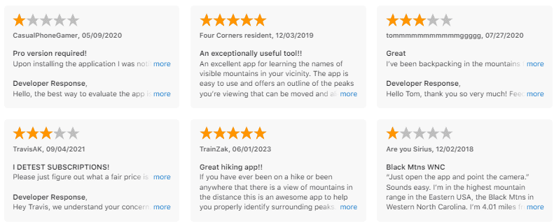
“The best app for identifying mountains. The AR feature is fun and educational, and the maps are incredibly detailed.” – 5-star review on the App Store.

“Perfect for backcountry skiing. Offline maps helped me navigate tricky areas without any hassle.” – 4.5-star review on PeakVisor’s site.

“I wish the app didn’t use as much data, but downloading maps before heading out solved most of my problems.” – 4-star review.
Overall Rating:
4.3/5 stars based on user feedback across multiple platforms.
How to Get Started with PeakVisor
Step-by-Step Guide:
- Download: Get PeakVisor from the iOS App Store or Google Play Store.
- Set Up: Choose your desired area and download maps for offline use.
- How to Use: Use the AR feature to identify peaks, or explore the 3D maps for trail and lift information.

Similar Apps
- FatMap – (Now integrated into Strava) 3D mapping focused on backcountry skiing, with more emphasis on route planning.
- Gaia GPS – Offers topographic maps and detailed terrain analysis, ideal for both skiing and hiking.
- Maprika – Custom map integration for navigation in less conventional areas, with group tracking features.
- PeakFinder – Provides real-time peak identification with offline functionality and a 360° panoramic view overlay.
- iSlope – Offers real-time GPS tracking with a social leaderboard, ideal for performance tracking on ski slopes.
Comparison: PeakVisor vs. PeakFinder vs. FATMAP vs. iSlope
| Feature | PeakVisor | PeakFinder | FATMAP | iSlope |
|---|---|---|---|---|
| Primary Focus | Peak Identification & 3D Mapping | Peak Identification | 3D Mapping & Navigation | Ski Performance Tracking & Social Leaderboard |
| Real-Time Tracking | Yes | Yes | Yes | Yes |
| Social Features | No | No | Limited | Yes |
| Offline Capability | Yes | Yes | Yes | Yes |
| AR Overlay | Yes | Yes | No | No |
| Cost | Free (Premium available) | One-time purchase | Free (In-app purchases) | Free (Premium available) |
Final Verdict
PeakVisor is an invaluable tool for skiers, snowboarders, and mountaineers who need to understand and navigate terrain in real-time. Its combination of 3D maps, AR peak identification, and offline capabilities make it a robust option for those who frequent the mountains. Although its subscription model may deter some casual users, the app’s advanced features and usability justify the cost for avid adventurers.
Download PeakVisor Today
Looking to explore the mountains with ease? Download PeakVisor and start navigating like a pro with 3D maps and AR peak identification!
